Newfoundland/Maritimes
road trip photos -
Page 3 of 3
by Oscar Voss
This photo collection, from my August 2003 road trip to Newfoundland
and the other Maritime Provinces of Canada, is divided into three pages.
Page 1 covers Newfoundland road signs
and pavement markings. Page
2 shows other sights along Newfoundland highways, plus licence plates.
The photos below cover the other Maritime Provinces,
as well as a little bit of northern Maine.
See also a
separate site for many of the souvenirs I brought back from the Maritimes,
including some for the Cabot Trail and the Confederation Bridge.
NOTE: In case you want more detail, clicking most of the photos below will call up enlarged, higher-quality (less .jpg compression) versions. Those alternate versions have larger file sizes, so please be patient while they download.
|

Page 2: miscellaneous Newfoundland
road photos, and licence plates
or return to Page 1: Newfoundland
road signs and pavement markings |
|
 |
 |
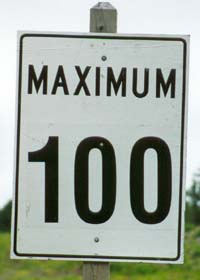
 A standard
Canadian speed limit sign (in km), taking advantage of the fact that "maximum" has the same meaning in English and French, so the sign can use only one word and still be fully bilingual. A standard
Canadian speed limit sign (in km), taking advantage of the fact that "maximum" has the same meaning in English and French, so the sign can use only one word and still be fully bilingual.
|
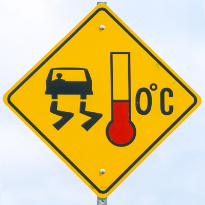
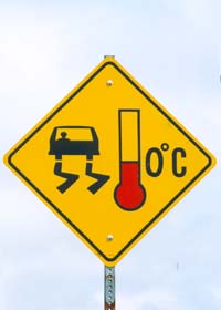
A bridge freeze
warning sign, here on route 101 in southwestern Nova Scotia, finesses the
bilinguality requirement by using only symbols. The sign is pretty confusing
at first, but drivers get the point (usually) soon enough after seeing
the same sign at several bridges in a row.
|
 |
 |
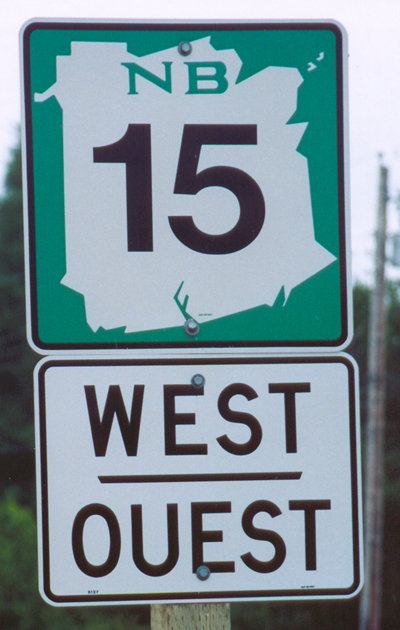
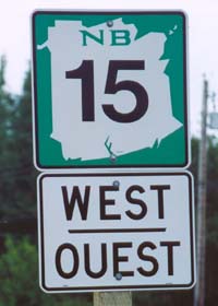
This
is the standard provincial route marker in New Brunswick, on this primary
highway east of Moncton. In New Brunswick (as well as on Prince Edward
Island, but not in Nova Scotia or Newfoundland), low route numbers are
reserved for major routes, with three-digit numbers (in New Brunswick,
going all the way into the high 900s) reserved for secondary routes.
|
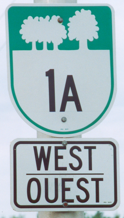
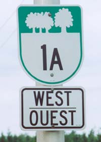
This is what
provincial route markers look like in the province of Prince Edward Island.
The route signage is not as consistently bilingual in PEI as it is in New
Brunswick (next door to Quebec, large French-speaking population). Bilingual
road signage is also somewhat uneven in Nova Scotia, and largely absent
in Newfoundland.
|
 |
 |
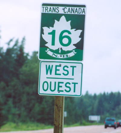
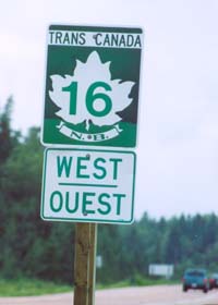
The special
Trans-Canada Highway marker used in all the provinces (customized with
the province name or abbreviation in the ribbon below the maple leaf).
This photo was taken in the two-lane branch of the TCH in New Brunswick
connecting to the Confederation Bridge to Prince Edward Island.
|
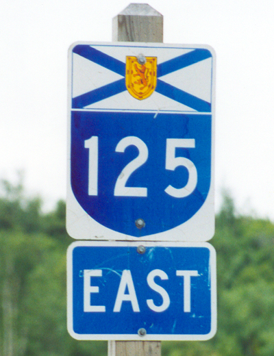
A route marker
on one of Nova Scotia's provincial arterials, here on the freeway between
the TCH and Sydney at the east end of the province. In Nova Scotia, the 100-series routes are the best ones, with many of them freeways or expressways. All are marked like this one, except for the segments (part or all of 104, 105, and 106) that are part of the Trans-Canada Highway.
|
 |
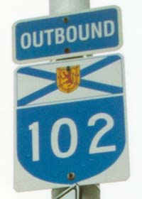 |
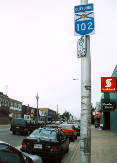
While
almost all of route 102 (connecting Halifax to the TCH at Truro) is a very,
very fast freeway, a few km at the southern end wind through the streets
of Halifax. On this and some other numbered highways in Halifax, the usual
directional banners are replaced with "inbound" and "outbound," or more
simply "in" and "out."
|
 |
 |
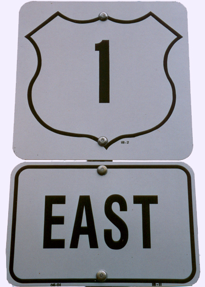
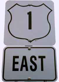
"Trunk" routes (which
used to be the main inter-regional highways in Nova Scotia, before the
100-series routes were built) are marked with a shield very similar to
that for U.S. routes. This photo was taken on a part of route 1, east of
Yarmouth, that has been bypassed by the newer, parallel route 101 arterial.
|
Nova Scotia's
secondary highways have rectangular brown route markers, with numbers 200
or above. This one in particular, in Mahone Bay on the scenic Lunenburg
Coast, used to be a branch of a trunk route. |
 |
 |
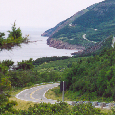
Many
highways in Nova Scotia, like the scenic Cabot Trail hugging the north
shore of Cape Breton Island in northeastern Nova Scotia, carry supplemental
scenic route markings like this, to help tourists explore various parts
of the province off the main arterials.
|
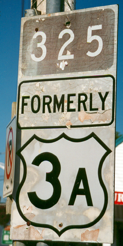
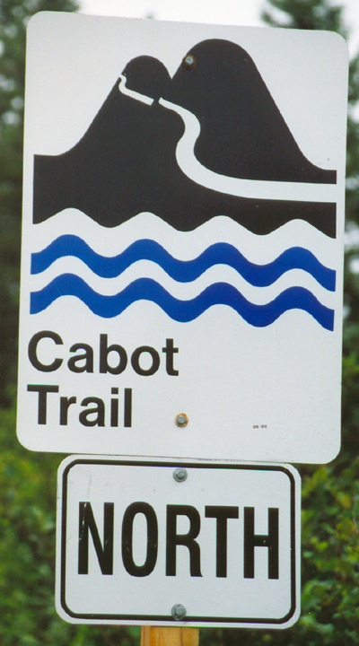
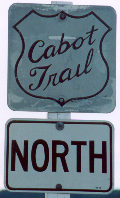
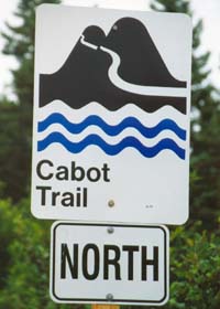
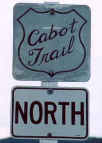
The Cabot
Trail happens to be the only trunk route in the province without a route
number, and so the only current marker for that route is the trail marker
above left. The historic route marker above apparently is the old route
marker, with the route name appearing in place of where the number would
go on a standard trunk route marker. This sign, on an old bridge east of
Margaree Harbour, may well soon be history, upon the opening of
a parallel new bridge under construction when I drove by in August 2003.
|
|
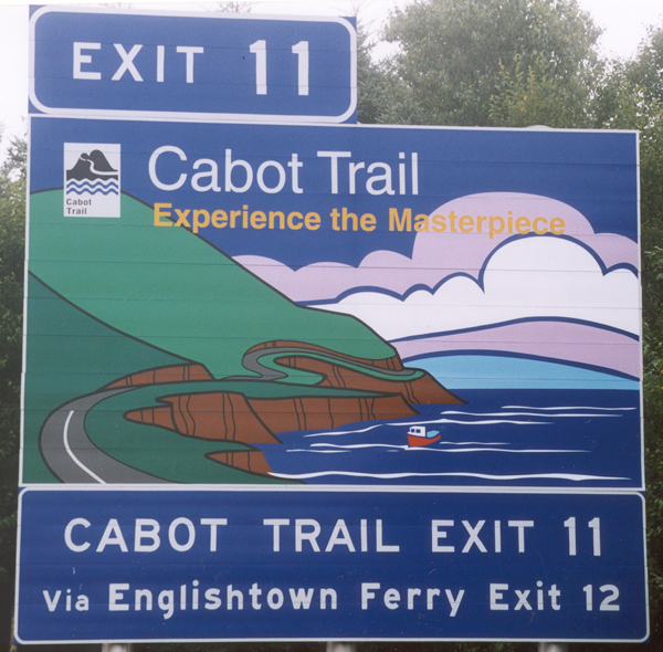
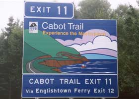
 As if it
weren't already well-advertised, this exit sign on TCH 105 encourages tourists
to "experience the masterpiece" of the Cabot Trail. This is at the eastern
junction of the Trail with the TCH; the Trail also connects to the TCH
at exit 7 to the west (I don't recall a similar exit sign there). Both
junctions are at-grade intersections, but they are assigned exit numbers along with all the other intersections on TCH 105. As if it
weren't already well-advertised, this exit sign on TCH 105 encourages tourists
to "experience the masterpiece" of the Cabot Trail. This is at the eastern
junction of the Trail with the TCH; the Trail also connects to the TCH
at exit 7 to the west (I don't recall a similar exit sign there). Both
junctions are at-grade intersections, but they are assigned exit numbers along with all the other intersections on TCH 105.
|
 |
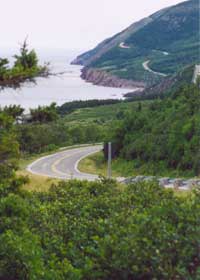 |
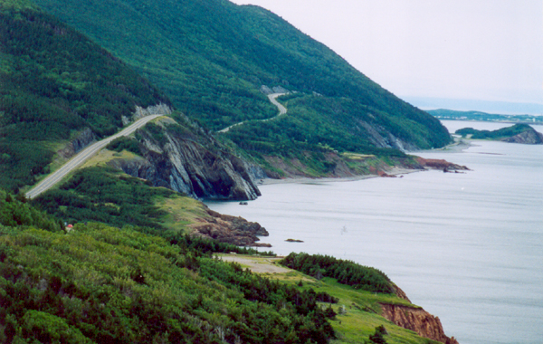
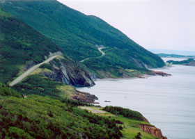
Two stretches
of the Cabot Trail at its most scenic, both along the west side of Cape
Breton Highlands National Park. (Some of the Trail outside the park is
cluttered with billboards and other signs.)
|
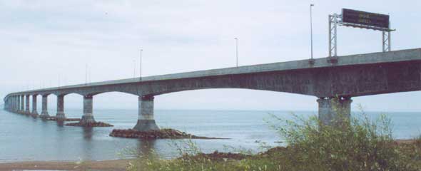 |
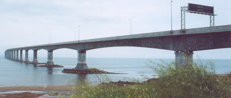
The west
end of the Confederation Bridge to Prince Edward Island, at Cape Jourimain
in New Brunswick. This toll bridge is two lanes wide and about 12 km long,
long enough to require gentle curves to be included in the bridge design
so motorists won't fall asleep on the span. (No scenic views from the bridge,
with a barrier about a meter high on both sides to cut down on crosswinds.)
It was opened in 1997 and replaced a ferry link to PEI from Cape Tormentine
to the south. That ferry no longer operates, with the former terminal on
the PEI side largely converted to a go-kart track, but a second ferry link
from the east end of PEI to Pictou, Nova Scotia is still open.
|
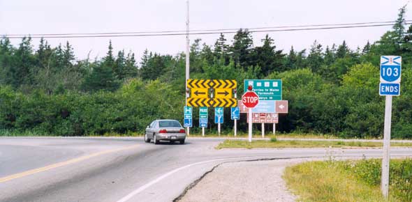 |
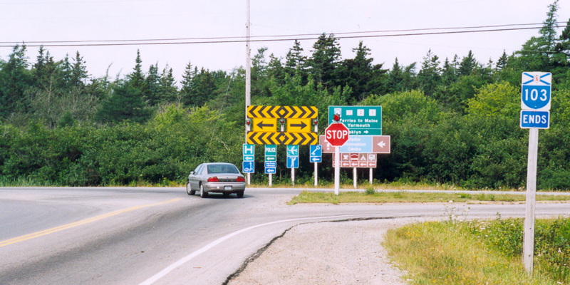
In
southwestern Nova Scotia, principal arterial routes 101 along the north
shore and 103 along the south shore converge on Yarmouth at the province's
west end. However, for some reason both highways end at local roads about
a km or two apart, with no direct connection between the two (or any indication of plans to build one) to complete the high-speed highway loop through southwestern Nova Scotia. The above shows the west end of route 103 east of Yarmouth, at Hardscratch Road heading into town.
|
 |
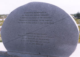 |
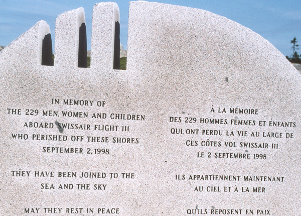
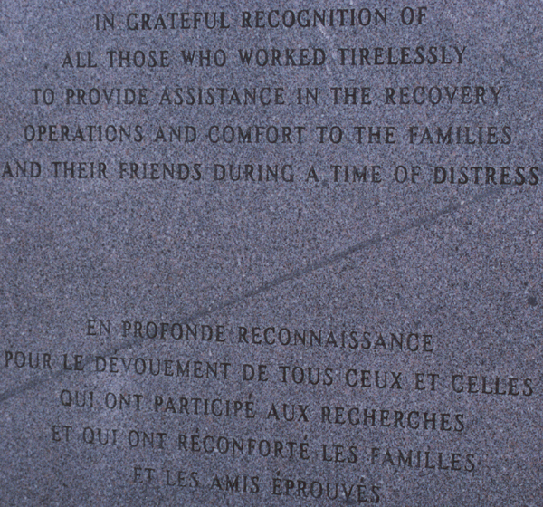
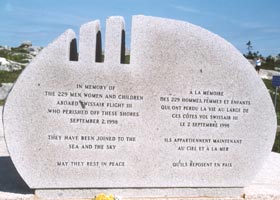
Peggy's Cove
on the scenic Lunenburg Coast south of route 103 was being "loved to death"
by tourists overwhelming what probably is otherwise a very scenic village,
on the Saturday morning I stopped by. By contrast, there were few visitors
at the quiet and dignified memorial west of the village to those who died
in the Swissair Flight 111 crash offshore in 1998. (By coincidence, I visited
a lot of air disaster sites that summer -- this one, another in Newfoundland
shown on page 2, and earlier in the summer "Ground Zero" in lower Manhattan
and the Flight 93 temporary memorial near Shanksville, Pennsylvania.)
|
 |
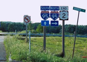 |
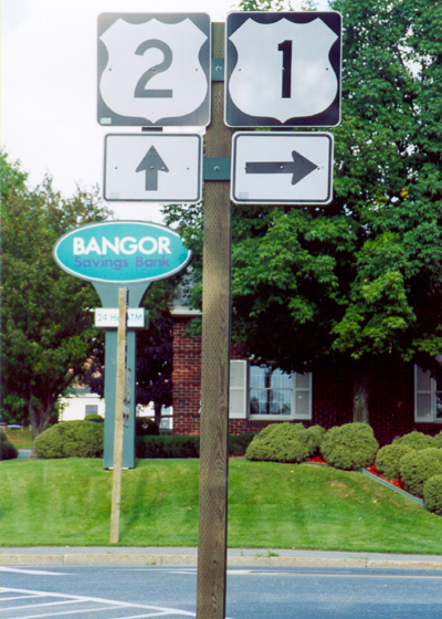
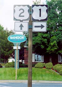
The junction
of the two lowest-numbered U.S. routes, in downtown Houlton, Maine just
west of the Canadian border.
|
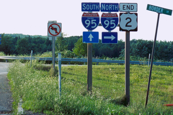
U.S. 2 ends
here just east of Houlton, at the last exit from Interstate 95 before it
ends at the Canadian border.
|
|
| Here ends my Newfoundland/Maritimes road photos collection.
Page 2: miscellaneous Newfoundland road photos, and licence plates
or go back to Page 1: Newfoundland road signs and pavement markings |
Alaska Roads main page (under construction as of October 2007, but has some useful information and links).
Questions, comments? Please e-mail me.
© Oscar Voss 2003-2004, 2007. |